
No Place for “No”: Falls Creek and the Silencing of Opposition
Timber harvesting in a community watershed as large and important as Falls Creek does not happen by accident. It can only occur because a decision has already been made by the Ministry of Forests that such activity is acceptable. That decision exists regardless of whether it is framed as a BC Timber Sales (BCTS) plan, a technical process, or an operational detail. The authority may be distributed, but the policy decision is real and it matters.
This reality is critical when governments and agencies engage the public. When an engagement process is designed in a way that constrains what people are allowed to respond to, it fundamentally alters the purpose of consultation itself. If key viewpoints such as opposition to any harvesting in a community drinking water watershed are excluded by design, the process risks functioning as validation rather than consultation. Constraining engagement in this way primarily serves institutional convenience, not public understanding or watershed protection.
Why survey design matters
Public engagement outputs such as surveys, summaries, and “what we heard” reports are not neutral artifacts. They are routinely relied upon by staff, executives, and ministers as evidence of public sentiment. They inform briefings, justify decisions, and shape future policy directions.
When opposition to harvesting is excluded from these tools, the resulting record can later be used to claim that the community was consulted and did not object, even when that is demonstrably untrue. This is not a technical oversight; it is a structural failure that produces a misleading public record. This concern applies regardless of how proposed activities are framed, including under the banner of wildfire mitigation.
Excluding “no harvesting” as an option does not make that position disappear. It simply removes it from formal documentation. And once a viewpoint is absent from the record, it has no pathway to reach decision-makers.
The role of community engagement
The role of a community engagement consultant is not to filter public opinion based on institutional convenience or jurisdictional limits. It is to gather and accurately document the full range of community perspectives, including those that challenge the premise of a project entirely.
The fact that BC Timber Sales may not have the authority to act on certain views does not make those views irrelevant. Lack of authority to act does not equate to a lack of responsibility to listen or record. Engagement is not about what can be implemented; it is about what is being said.
If a community engagement framework precludes certain outcomes because of prior government decisions, those constraints must be made explicit and documented upfront. They cannot be embedded silently in survey design, where participants reasonably assume their views are being fully captured.
Accountability depends on the record
If no one involved in an engagement process is willing or able to document opposition to harvesting, then there is no accountable pathway for that opposition to reach senior decision-makers. This severs the connection between the public and those responsible for weighing risks, trade-offs, and long-term consequences, especially in something as fundamental as drinking water protection.
At the same time, communities are being asked to give significant amounts of time and energy to these processes. People show up after work, step away from family responsibilities, and engage in good faith. To do so while structuring engagement in a way that excludes deeply held and widely expressed concerns is simply unfair.
For the record
For the record, many community members, myself included, object to any BC Timber Sales activity within the Falls Creek community watershed. We will continue to advocate for watershed protection, transparency in decision-making, and engagement processes that genuinely reflect the voices of the people most affected. If you haven’t yet, sign the petition: https://www.friendsoffallscreek.ca/petition
Protecting drinking water requires more than process. It requires honesty about constraints, respect for community input, and a public record that tells the full truth, not just the convenient parts. Communities deserve engagement processes that are transparent about their limits and willing to formally record dissent, especially when drinking water is at stake.
Where Wildfire Risk Lies for the Bonnington–Beasley Communities: A FireSmart Perspective
This article has been reviewed and is supported by a FireSmart BC wildfire scientist whose work focuses on home and community protection.
Wildfire risk in the Bonnington–Beasley area is not evenly distributed across the landscape, and understanding where that risk is concentrated matters when evaluating claims about wildfire mitigation in the Falls Creek watershed.
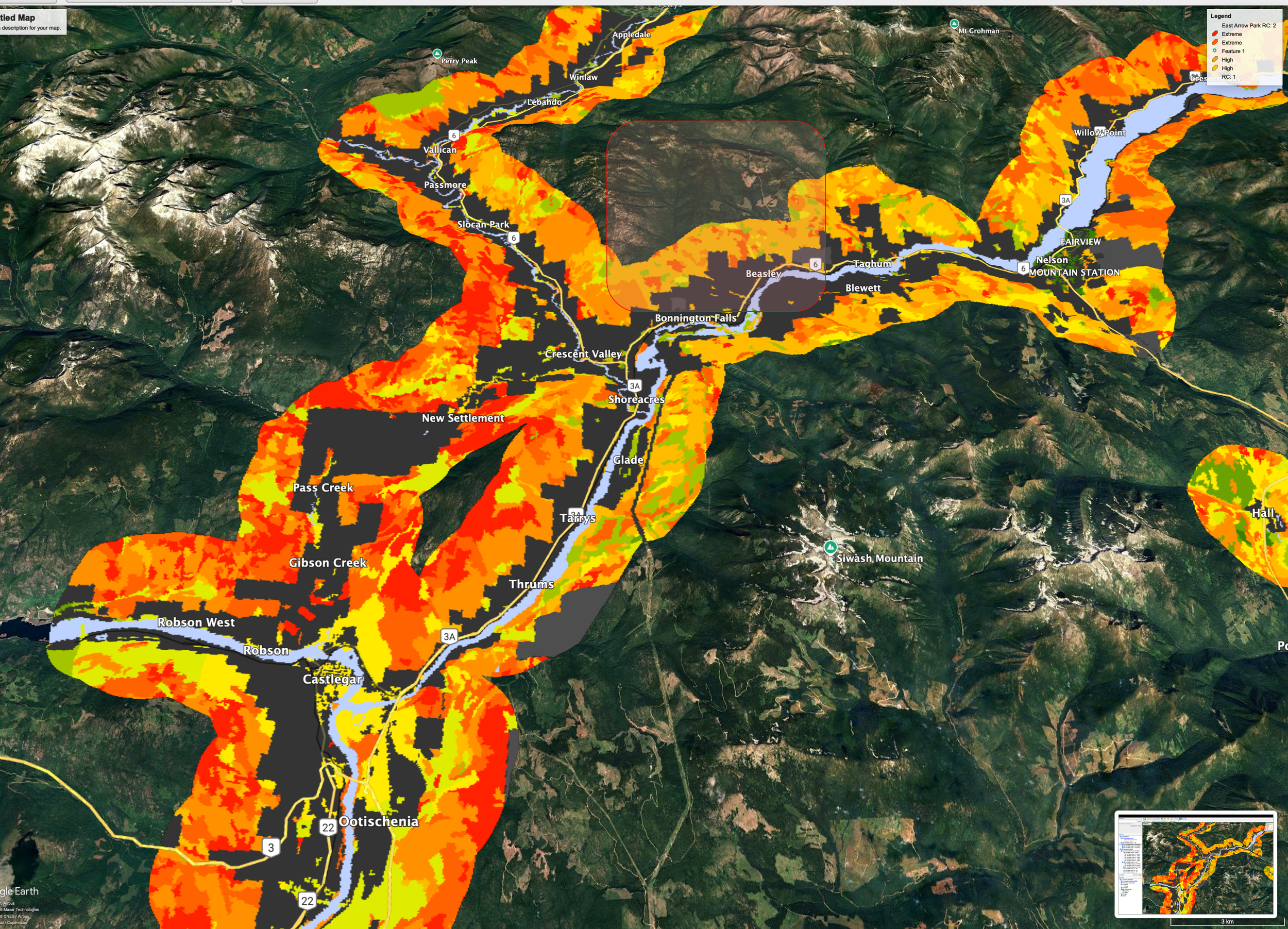
The map above shows the Wildland–Urban Interface (WUI) and wildfire threat classes across the West Kootenays. These provincial datasets are designed to identify areas where wildfire is most likely to threaten homes, infrastructure, and human safety. WUI mapping identifies where wildfire poses the greatest risk to communities and infrastructure; it does not predict where fires will start or how large they may become.
What this map clearly shows is that the highest wildfire risk to communities is concentrated West of Bonnington and Beasley (shaded in red box), along the valley bottom and adjacent slopes where homes, roads, and critical infrastructure are located. These areas fall within the WUI, where wildfire mitigation efforts are most effective and where FireSmart guidance consistently prioritizes action.
In contrast, much of the Falls Creek watershed lies outside the core WUI zone, farther upslope and upstream from residential development. While wildfire can and does occur in remote forested areas, decades of fire science demonstrate that treatments far from homes provide limited and uncertain protection to communities, particularly when compared to fuel reduction and FireSmart work carried out close to structures.
Under extreme fire weather conditions, wildfire can spread rapidly across many types of terrain; however, research consistently shows that structure survival is primarily determined by conditions immediately surrounding homes, including building materials, defensible space, and the management of nearby vegetation.
FireSmart Canada guidance emphasizes that:
The most effective wildfire risk reduction occurs within approximately 30 metres of homes
Community protection is driven by home ignition potential, not large-scale landscape treatments
Treating forests several kilometres away does not reliably prevent ember-driven fire spread into communities
This distinction is critical. Framing industrial logging deep within a community watershed as “home protection” risks conflating landscape fire behaviour with actual risk to people and drinking water systems.
That does not mean wildfire risk should be ignored. It means mitigation efforts should be targeted where they are proven to work. That is primarily in the WUI, around homes, along evacuation routes, and in areas where people live and work, rather than in sensitive headwater areas where the benefits to community safety are uncertain and the risks to drinking water are real. In steep headwater watersheds, road building and forest disturbance can also introduce long-term risks, including erosion, sediment delivery, and altered hydrology, without providing clear or measurable reductions in community wildfire risk.
Understanding where wildfire risk truly lies allows for more honest, evidence-based conversations about how to protect communities while safeguarding the watersheds they depend on.
Bonnington and Beasley residents have started a FireSmart committee that can be reached at FallsCreekFireSmart@gmail.com. The formation of a local FireSmart committee reflects a community commitment to reducing wildfire risk around homes and infrastructure. However, participation in FireSmart does not imply endorsement of industrial logging or fuel treatments in areas outside the WUI, nor does it constitute community consent for forestry operations within the Falls Creek watershed.
BCTS Planning Session
Community Raises Alarm Over Logging Plans in Falls Creek Watershed
Around 60 Bonnington/Beasley Residents were at the BCTS planning session on January 14th, many of which are expressing growing concern over proposed BC Timber Sales (BCTS) activities in their community watershed, citing a lack of transparency, unresolved safety risks, and what many describe as a fundamentally flawed approach to wildfire protection.
Not all Beasley residents were in attendance as Solita Work was denied entry.
No Clear Plan, Conflicting Answers
A recurring theme from the engagement session was the absence of a clear plan. Despite repeated questions, BCTS representatives were either unable or unwilling to articulate guiding principles, concrete objectives, or operational details. Participants reported receiving three different answers to the same question from three separate BCTS staff. Unfortunately Mark Tallman was ill and not in attendance. Many answers were prefaced with what he would likely say, or did not know the details of his work. This was a significant barrier to receiving specific information.
Throughout the session, BCTS representatives repeatedly relied on conditional language such as “we hope we can do this” and “we hope policy changes will support this.” When asked for specifics about timelines, treatments, safeguards, or monitoring many responses amounted to “I don’t know.” We were also told that long term monitoring has not occurred because it is expensive. Thus planning is based on fragmented data and modelling.
Community members were told that detailed plans could not yet be shared because they were still being developed using community input. However, many felt this explanation was circular and dismissive, especially given that BCTS documents already contain answers to some of the questions raised, documents that residents had in hand. BCTS staff maintained they could not share specifics.
Several inaccurate or misleading statements were made during the session, including assertions that local roads are not being impacted by current logging activities in the woodlot at the top of Mountain View Road. It was described as “just fine”. When asked if riparian zones could be reduced as a result of an increase in another riparian zone, the response was that logging “never happens in riparian zones because it’s illegal.” There was no opportunity during the share-out to challenge or correct these claims, nor any structured way to follow up on concerns raised.
Logging Truck Route Raises Safety Concerns
One of the most alarming revelations involved the logging truck route currently used for the woodlot at the top of Mountain View Road. Trucks travel down Mountain View Road—despite known infrastructure damage, including a sinkhole at a hairpin turn–then along Thompson/Bonnington Road before turning at the mailboxes onto Brown Road and down Viewridge to the highway. It is too dangerous for the trucks to access the highway via Bonnington Road. There have already been a “couple of close calls”, so highways asked for the change. Although BCTS was not forthcoming with exact routes, it is reasonable to assume it will be the same for other logging operations.
This route passes a school bus stop and a public transit stop, and is heavily used by children walking to catch the bus or access the park on Brown Road. Residents were given no information about truck volumes, schedules, speed management, or safety accommodations for pedestrians and children. For many, this omission underscored how little practical planning has been done.
BCTS was emphatic that no access routes to the watershed for logging trucks had been secured. Access requires crossing private land, for which no agreement has been finalized. If access is not secured through Mountain View Road, it is unclear where alternatives could be and BCTS was not forthcoming with this information.
Indemnity Insurance Declined
A further point of concern raised by community members is that George Edney declined to provide indemnity insurance to the community in relation to proposed activities in the watershed.
For residents, this raises serious questions about risk and accountability. If damage were to occur, whether to roads, water infrastructure, private property or drinking water quality, the absence of indemnity protection leaves the community exposed, while decision-makers and proponents, and contractors remain shielded. Many felt this decision was inconsistent with the level of risk being asked of a community whose sole drinking water source could be affected. Concerns were raised about how an already stressed water system at full capacity could adapt to more disturbances in the watershed.
Co-Creation in Name Only?
BCTS framed the engagement as a form of co-creation, yet many residents questioned how this could be the case when foundational conversations about community values had never occurred.
Participants noted that if co-creation were truly the goal, the process should have begun at least eight months earlier starting with discussions about what Bonnington and Beasley residents value most, followed by an iterative planning process built together over time. Instead, residents were asked to react to a largely pre-defined direction, with limited ability to influence scope, assumptions, or alternatives. Selkirk forestry students were present to facilitate the discussions, if Environmental Planning students would have been given those roles, it may have encouraged deeper learning and holistic viewpoints.
Compounding this frustration was the fact that participants were not informed until late in the process of table discussions that we needed to distill our wide ranging list of concerns into a single question, leaving many important concerns unheard and unanswered.
A “Home Protection Zone” That Extends Kilometres Into the Watershed?
At table discussions, participants questioned how the project could be described as a “home protection zone” when FireSmart evidence consistently shows that the most effective wildfire risk reduction occurs within approximately 30 metres of structures, not 4 km into a community watershed.
Fire does not respect boundaries drawn on a map, residents noted, making it difficult to see how isolated wildfire risk reduction treatments deep in the watershed would meaningfully protect homes. This concern was echoed by a few residents who also felt Falls Creek watershed relatively well suited to manage wildfire risk as it currently stands given the humidity it creates.
FireSmart science consistently shows that defensible space close to structures is what most reliably reduces home ignition risk, while the effectiveness of landscape-scale thinning deep in watersheds is still a subject of scientific debate.
Wildland–Urban Interface Mapping Raises Broader Concerns
One of the most significant takeaways for many attendees was the Wildland–Urban Interface (WUI) mapping that stretches from the Falls Creek junction toward Kaslo. The operator of the woodlot at the top of Mountain View Road described the project as a “pilot” that could inform how multiple watersheds along the corridor might be treated if BCTS proceeds with its mapped approach.
For residents, this raised the stakes considerably. If other communities understood that what happens in Falls Creek could set a precedent for watershed-level logging under the banner of wildfire mitigation, many believe there would be widespread concern and opposition.
Hope, Conditions, and Community Power
Despite the frustration, some comments offered cautious hope. Some residents suggested that the community could impose conditions on any activity in the watershed, such as selective logging practices or robust water contingency plans. Another belief was stated that the project could be stopped entirely if that is what the community ultimately wants.
These statements reinforced a sense among attendees that the situation is not a foregone conclusion and that strong, organized community opposition could still influence the outcome.
Water First: Lived Experience and Ongoing Impacts
Concerns about water quantity and quality were not abstract. Many raised the lack of water in summer months that is already occuring. One participant from Taghum shared that their community is still dealing with water issues stemming from logging on private land above their watershed last summer, with no agency taking responsibility for the damage. We were given no assurances by BCTS representatives on these points, but rather a fallback to wildfire protection concerns.
Participants also discussed the idea of recognizing the Falls Creek watershed as a natural asset living infrastructure with measurable economic value through clean drinking water, ecosystem services, and avoided treatment costs. From this perspective, logging poses not just an environmental risk, but a financial one.
Falls Creek also seems well suited to withstand a wildfire in some sense as it is steeps, creates it’s own humidity and cooling affect as well as is close by a natural body of water for fighting fires.
Bonnington Improvement District Takes a Firm Stand
Importantly, the Bonnington Improvement District (BID) has formally stated its opposition to BCTS activities within the Falls Creek watershed. BID has made clear that drinking water protection must take precedence and has indicated a willingness to negotiate land expropriation if necessary to prevent pollution and protect community water sources from logging impacts.
Friends of Falls Creek received a grant from West Coast Environmental Law. This grant money supported BID to work with Environmental Lawyer, Ben Isitt who has sent a letter to BCTS with their formal objection. The deadline for a response from BCTS was January 15th.
Community Solidarity Grows
While many left the session frustrated by the lack of answers, one positive outcome stood out: connection. Residents from across the area were able to share experiences, align concerns, and recognize the broader implications of what is being proposed.
At multiple tables participants were largely opposed to logging in the watershed and raised consistent, well-founded concerns about safety, water, wildfire science, and governance.
As one attendee summarized: if this is truly about protecting homes and communities, then the science, the planning, and the engagement must reflect that. Right now, many feel it does not.
Given the state of our world right now, ecosystem health should be top priority to support all our relations.
For more information or to get involved sign up to be a member of Friends of Falls Creek, and/or sign the https://www.friendsoffallscreek.ca/petitionpetition.
FOI - What’s really happening in the Falls Creek Watershed.
BC Timber Sales has been planning for years for major industrial logging in the Falls Creek Watershed, which hundreds of Bonnington and Beasley residents rely on for our drinking water supply (along with aquatic species and other wildlife in Falls Creek and Kootenay River).
Through Freedom of Information releases (including 262 pages obtained this week) we know:
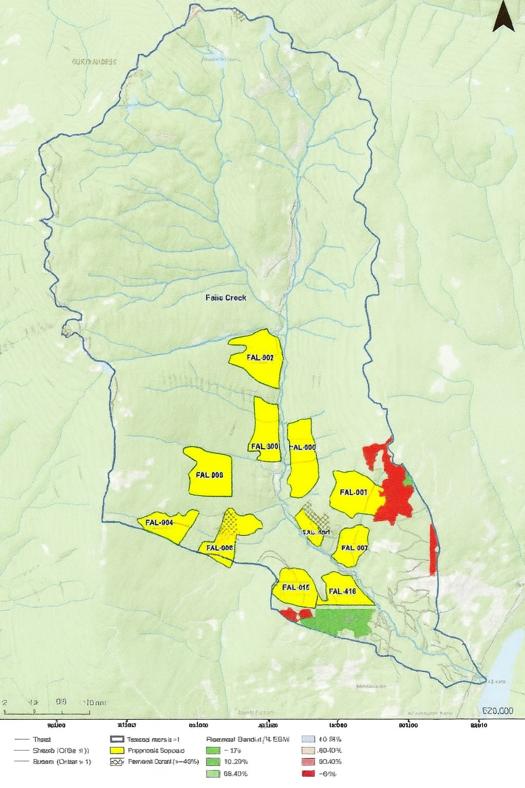
BCTS has been planning for roads and cutblocks in Falls Creek since at least 2023;
developed maps showing 11 cutblocks in Falls Creek – months before so-called “community engagement” began with residents on a “Community Watershed Forestry Plan”;
While BCTS messaging emphasizes “ecosystem health”, “climate resilience” and “wildfire mitigation”, BCTS staff concede in their internal documents that “ultimately our future activities are in the form of blocks, roads, fuel treatments, and silviculture decisions”;
The engagement process has not been designed to represent the community. BCTS has refused to hold a “group meeting at Taghum Hall without … filtering”, and the engagement consultant, Cathy Scott-May, was hired for strategic communication and resource-management messaging, rather than to represent or convey community concerns to BCTS. On November 9, 2025, when residents asked Cathy for maps showing the location of potential cutblocks, she stated that “there are no maps of preliminary areas.” However, the FOI documents reveal that BCTS has had maps showing polygons of 11 proposed “blocks” since at least April 2025. This discrepancy has undermined public trust in the engagement process.
Join the Friends of Falls Creek to help protect our watershed, and protect your property value by advocating for (1) targeted non-commercial wildfire risk reduction, with BC government funding, and (2) leaving the Falls Creek Old-Growth Forests standing, to continue filtering and storing our fragile water supply in perpetuity.
Watershed Festival
A music festival for community and for gratitude for nature’s life giving source: Nov 16th Taghum Hall 1-3pm
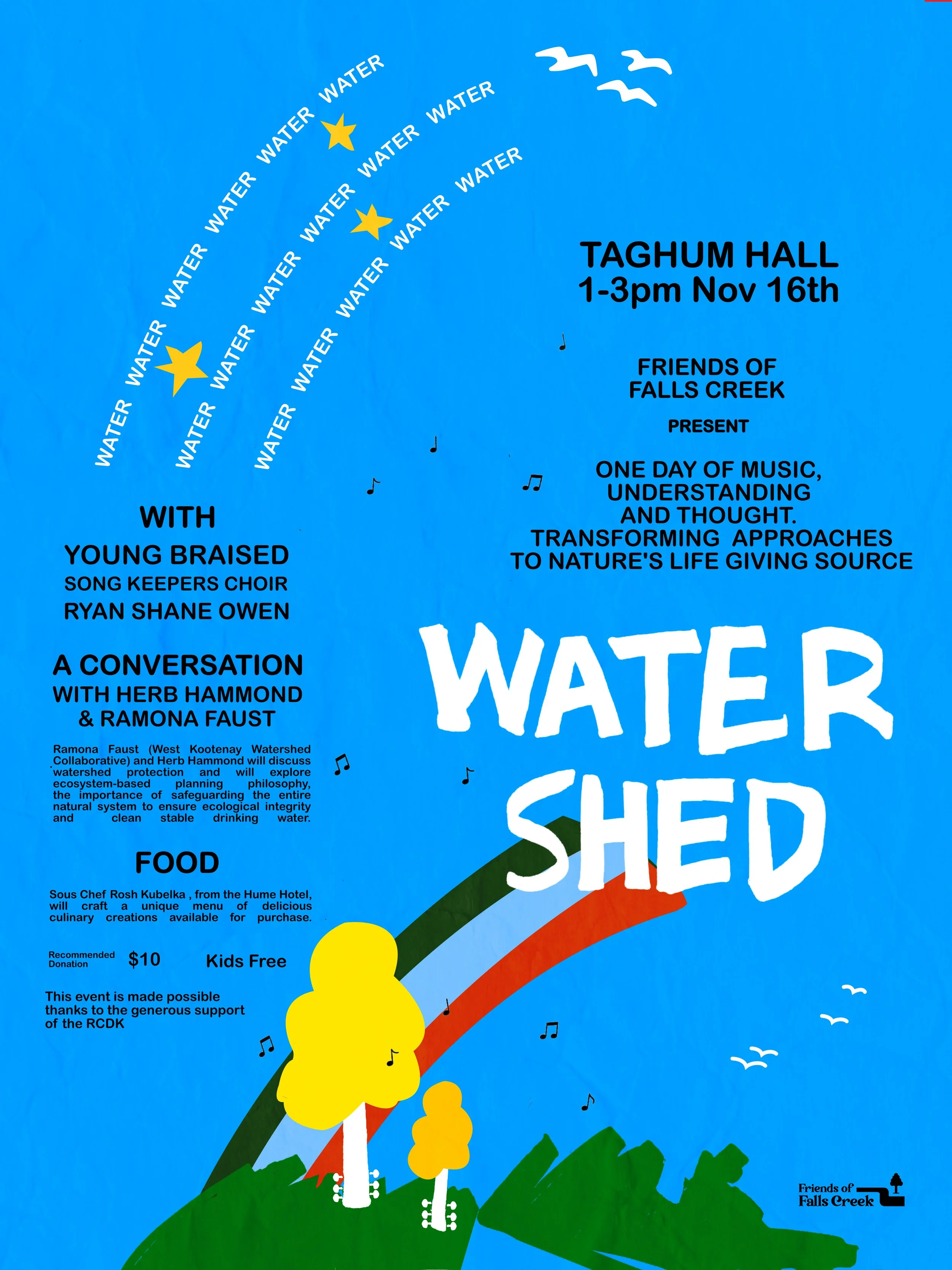
Friends of Falls Creek is hosting a fundraising festival in order to support the Bonnington and Beasley communities against BC Timber Sales commercial logging in the watershed. A day of music, thought and gathering to show gratitude for nature’s life giving source. With bands and speakers at the forefront of the discussion, we hope you can join us on this first meeting at Taghum Hall on November 16th. All proceeds will go towards putting together a robust strategy against commercial logging and protecting our water source.
Brilliant music featuring: Young Braised, Song Keepers Choir and Ryan Shane Owen
Chef Rosh Kubelka of Hume Hotel will be sharing some of his food favorites available for purchase.
Suggested Donation $10 and kids are free. Water is life, water is love.