
Where Wildfire Risk Lies for the Bonnington–Beasley Communities: A FireSmart Perspective
This article has been reviewed and is supported by a FireSmart BC wildfire scientist whose work focuses on home and community protection.
Wildfire risk in the Bonnington–Beasley area is not evenly distributed across the landscape, and understanding where that risk is concentrated matters when evaluating claims about wildfire mitigation in the Falls Creek watershed.
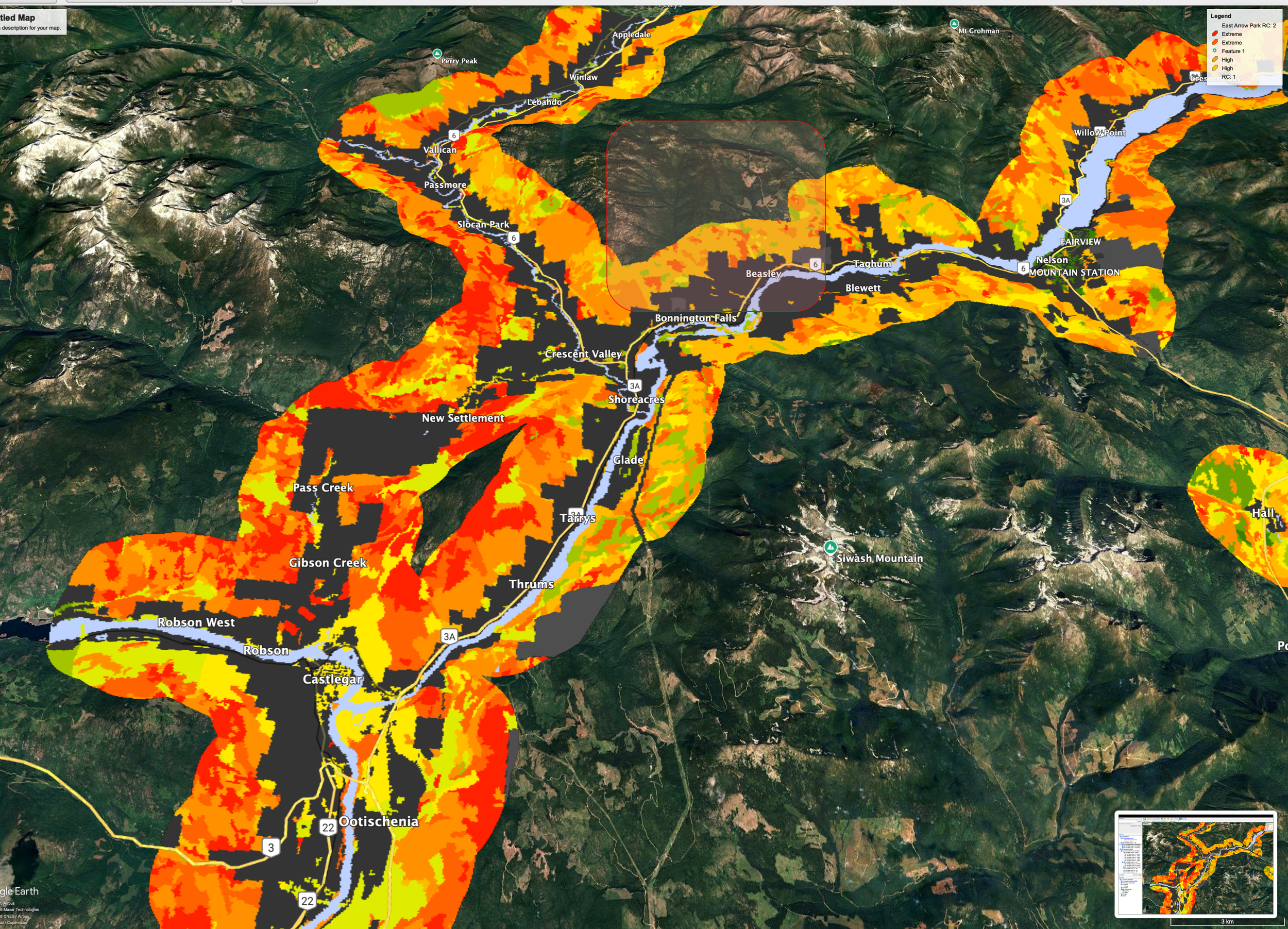
The map above shows the Wildland–Urban Interface (WUI) and wildfire threat classes across the West Kootenays. These provincial datasets are designed to identify areas where wildfire is most likely to threaten homes, infrastructure, and human safety. WUI mapping identifies where wildfire poses the greatest risk to communities and infrastructure; it does not predict where fires will start or how large they may become.
What this map clearly shows is that the highest wildfire risk to communities is concentrated West of Bonnington and Beasley (shaded in red box), along the valley bottom and adjacent slopes where homes, roads, and critical infrastructure are located. These areas fall within the WUI, where wildfire mitigation efforts are most effective and where FireSmart guidance consistently prioritizes action.
In contrast, much of the Falls Creek watershed lies outside the core WUI zone, farther upslope and upstream from residential development. While wildfire can and does occur in remote forested areas, decades of fire science demonstrate that treatments far from homes provide limited and uncertain protection to communities, particularly when compared to fuel reduction and FireSmart work carried out close to structures.
Under extreme fire weather conditions, wildfire can spread rapidly across many types of terrain; however, research consistently shows that structure survival is primarily determined by conditions immediately surrounding homes, including building materials, defensible space, and the management of nearby vegetation.
FireSmart Canada guidance emphasizes that:
The most effective wildfire risk reduction occurs within approximately 30 metres of homes
Community protection is driven by home ignition potential, not large-scale landscape treatments
Treating forests several kilometres away does not reliably prevent ember-driven fire spread into communities
This distinction is critical. Framing industrial logging deep within a community watershed as “home protection” risks conflating landscape fire behaviour with actual risk to people and drinking water systems.
That does not mean wildfire risk should be ignored. It means mitigation efforts should be targeted where they are proven to work. That is primarily in the WUI, around homes, along evacuation routes, and in areas where people live and work, rather than in sensitive headwater areas where the benefits to community safety are uncertain and the risks to drinking water are real. In steep headwater watersheds, road building and forest disturbance can also introduce long-term risks, including erosion, sediment delivery, and altered hydrology, without providing clear or measurable reductions in community wildfire risk.
Understanding where wildfire risk truly lies allows for more honest, evidence-based conversations about how to protect communities while safeguarding the watersheds they depend on.
Bonnington and Beasley residents have started a FireSmart committee that can be reached at FallsCreekFireSmart@gmail.com. The formation of a local FireSmart committee reflects a community commitment to reducing wildfire risk around homes and infrastructure. However, participation in FireSmart does not imply endorsement of industrial logging or fuel treatments in areas outside the WUI, nor does it constitute community consent for forestry operations within the Falls Creek watershed.